India Publication of Survey of India ALP Map: Five Strategic Implications
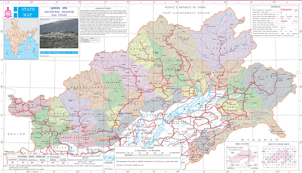
In a Press Release on August 07, the Ministry of The Government of India, in consultation with State Government of Arunachal Pradesh, has identified a total of twenty-seven (27) places/features located in Arunachal Pradesh, by standard place and feature names on the official maps of Survey of India (SoI).
Identifying them formally on the Survey of India map of Arunachal Pradesh is aimed at facilitating their accurate recognition and better awareness among the public at large.
These twenty-seven (27) places/features so identified on the Survey of India map of the State of Arunachal Pradesh, are as under:
Arunachal Pradesh (27) | ||
S.No. | Name of Place | Feature Type |
1 | Longju | Land area |
2 | Maja | Land area |
3 | Bisa | Land area |
4 | Dzo La | Pass |
5 | Riza La | Pass |
6 | Pukur La | Pass |
7 | Thag La | Pass |
8 | Sambho Sarovar | Lake |
9 | Bara Kundun | Land area |
10 | Chhota Kundun | Land area |
11 | Dhan Bari | Land area |
12 | Pritnagar | Land area |
13 | Buddhamandir | Land area |
14 | Jairampur | Land area |
15 | Teritnagar | Land area |
16 | Ramnagar | Land area |
17 | Jaswant Garh | Land area |
18 | Sagar | Land area |
19 | Padma | Land area |
20 | Jyotinagar | Land area |
21 | Baisakhi | Land area |
22 | Sher-e-Thapa Memorial | Monument |
23 | Chhota Ropuk | Land area |
24 | Bara Ropuk | Land area |
25 | Shivaji Nagar | Land area |
26 | Sunpura | Land area |
27 | Kamlang Nagar | Land area |
The map of Arunachal Pradesh, with additional places/features, can be viewed at https://surveyofindia.gov.in/pages/state-maps.
The publication of the official map by the Survey of India has several strategic implications. Firstly India has asserted sovereignty over Arunachal Pradesh issuing a definitive Map possibly for the first time publicly including a photo of the Towang Monastery.
Secondly this is symbolic not just in terms of publication of the Map but also the photograph of Towang alongside given that one of the roots of Chinese claims are based on access to the Monastery having religious and cultural significance with Tibet or the Xijang Autonomous Region. The move is aimed at reinforcing India’s absolute sovereign and legal jurisdiction over these territories. Among the places is also the border village of Longju, controlled by China since 1959 but within the Indian claim line indicating an affirmation of the claimed areas in the State.
Thirdly, release also saw issue of standard names for 27 places and geographical features in Arunachal Pradesh which appears to be a repartee to the Chinese publishing their versions of the names in Mandarin from time to time in the past in what has been called as cartographic legal warfare by some as part of China’s Three Warfare strategy, the other two being media and psychological.
Fourthly Map provides now absolute administrative as well as operational clarity down to the last citizen of India who wishes to access the details which were previously only available to military and civilian officials of the Government of India. This reinforces Indian claims to the State which China has disputed from time to time.
Fifthly the Map was published a day after 36th meeting of the Working Mechanism for Consultation & Coordination on India‑China Border Affairs (WMCC) was held on 06 August in New Delhi.
As per the Ministry of External Affairs Press Release the two sides engaged in frank discussions and reviewed the situation along the Line of Actual Control (LAC). Further, it was underlined that maintaining peace and tranquillity in the border areas is essential for the overall development of bilateral relations. Both sides agreed to continue to use existing diplomatic and military channels, including the WMCC, local commander‑level meetings and other agreed mechanisms, to resolve outstanding issues and avoid misunderstanding and miscalculation along the LAC.
As a follow up to the outcomes of 24th SR Talks, two sides held detailed exchanges on issues related to boundary delimitation, border management, mechanism‑building and trans‑border cooperation.
With the Publication of the Map by Survey of India there can be concrete discussions on the boundary alignment amongst other issues.
The Indian side reiterated the need for early convening of the next meeting of the Expert Level Mechanism on trans‑border rivers and emphasized the importance of sharing technical details on upstream projects.
It remains to be seen, how China responds to this development.


Comments